Amended 1/10/2010 - You are here: Jubilee River Home Page > JR - key facts > What's wrong with the Jubilee River? > Myrke flood bank - geo-textile problem > Myrke flood bank degradation - August 2010 > The Jubilee River story > How to contact me > Jubilee River guided tours
‘THE MYRKE’ EMBANKMENT OF THE JUBILEE RIVER AT DATCHET
CURRENT STRUCTURAL CONDITION
AN UNQUALIFIED OBSERVATION 9.4.09. by Ian Thompson
The Myrke Embankment was dismantled and replaced during 2004 over a length of 300 metres at a cost of approximately £1.4m due to the original structure having failed and being irrecoverably damaged in the November/December 2002 and January 2003 flood events. The EA deemed the original structure to have been complete in November 2002 following test flow assessment.

Currently the replacement structure shows numerous areas of extensive surface erosion within the new construction which has taken place over the past four years. Additionally, the new/old embankment joint is extensively slumped as to affect the redesignated maximum capacity of the Jubilee River water flow volume to an even lower capacity.

As a matter of record the Jubilee River has been subject to major design failures as set out within the WS Atkins consulting engineer’s reports which confirm incorrect construction has resulted in an operating capacity significantly lower than originally specified and a river bend radius has been constructed at ‘The Myrke’ that is not in compliance with the codes of design practice, the bend having a tighter radius than specified for good practice; thus increasing operating forces and stresses on the Myrke bend structure.
Both of the above design and construction failures results in an ongoing increased risk of overspill or breach failure. This risk was stabilised in 2004 by a new design of embankment by WS Atkins Ltd. In order to maintain the structural integrity of the new embankment, it must not be able to erode at an excessive or extensive degree.
An erosion margin is built into the current construction. However, that margin would not be expected to show the current level of margin penetration over such a short timescale following construction completion.


There are several forms of surface erosion currently visible:
1) EMBANKMENT PARAPET SURFACE Loss of top cover consisting of earth fill loss between the surface mat and the geotextile. The plant material within the covering mat has compacted down in considerable areas across the horizontal face and in some places has eroded away to expose the wire matting. On much of the parapet topping the plant material has reduced to a thin covering of moss.

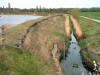
2) EMBANKMENT EAST FACE MYRKE DITCH This face has a step divided batter (slope) with a short near horizontal land tapering into a continuous slope from the parapet to the base of the Myrke Ditch. The length of the horizontal land is 100m.
Along the parapet edge to the slope joint much of the plant content of the mat has either completely eroded away or become detached from the mat and slumped down to the horizontal level. Loss of the plant cover has resulted in exposing the close weave geotextile structural membrane to ultra violet degradation over approximately 1 metre depth along the east elevation. (Approx 100m)

Where the mat is empty of any organic content there are voids between the mat wire and the fine weave geotextile beneath. Within these voids light dry organic soil is eroding from below the top structural soil level wrapped in geotextile and down to the horizontal land supporting this slump. The result is that the effective embankment width has been reduced at these locations exposing the internal structure to increased weathering and hastening erosion along the length of this face.
Similar plant material loss from the mat covering the steep embankment slopes projecting down to the Myrke Stream confirm that the embankment materials are migrating into the stream and are being washed away, obstructing the stream and accelerating stream bed plant growth resulting in water flow obstruction.

The plant wire mat is exposed along the stream embankment where this material has eroded away for considerable areas along the slope faces, generally at approximately a 45° angle and in places steeper.
It is noted in areas where the mat is empty of any organic material that the underlying layer is fine weave plastic geotextile, which prevents root penetration and water retention to organic materials above, thus resulting in air gaps, which accelerate loss of the organic material covering.
3) EMBANKMENT WEST FACE JUBILEE RIVER This face has a steep plant covered sloping face projecting to a lower horizontal land and appears to be generally in good condition. However the recent February flood event resulted in use of the Jubilee River up to 130 cumex flow which resulted in small patches of visible localised plant surface loss and exposure of the wire mat and geotextile. This can be resolved with repair patches.

4) EMBANKMENT NORTH PROTECTING ‘THE MYRKE’ HOUSING ESTATE The joint between the replaced embankment and the original embankment has settled to a considerable extent (approx 0.8m). The centre of this settlement contains a circular (approx 1m diameter) depression (approx 15cm) deep further reducing the effective containment and indicating a point of weakness and a location for early over topping at high flow volumes within the Jubilee River.

5) EMBANKMENT FOOTING ADJACENT TO POCOCKS LANE ROAD BRIDGE The plant and soil fill within this area was washed out thus exposing the stone gabion bank foundations. This was caused by the Myrke Pump Hose not being secured at its discharge end, not being long enough and not sited correctly or protected while in operation during the February 2009 flood event. The hose was destroyed during its use and was an unsafe action by the EA. Minor repairs to the embankment are possible and a fixed pump discharge capped pipe from the pump yard should be considered under safe working practice.

VOLUME OF CONTAINED WATER FLOW CURRENTLY POSSIBLE WITHOUT OVERTOPPING RISK WITHIN THE JUBILEE RIVER
The original design capacity of the Jubilee River was 215 cumex. The actual safe design capacity stated within WS Atkins report (Ref 1) of July 2004 is 145 cumex. The claimed capacity stated by the EA based upon their completed rectification works is 180 cumex. Atkins states 180 cumex which would risk overtopping in critical locations or 165 cumex in contained flow.
In 2003 the water level downstream of Pococks Lane Bridge was 19.33m AOD
Flow in the Jubilee River was 144 cumex (Ref 2).
During February 2009 the water level downstream of Pococks Lane Bridge was 18.675m AOD Flow in the Jubilee River was 127-130 cumex.
Land levels in field and road east of the Jubilee River are 18.409m AOD and drop to 18.3m AOD along Pococks Lane/Eton Road. Land levels continue to drop towards central Datchet. (Ref 3).
A water level of 18.44m in the Jubilee River flowing at 90 cumex (Ref 4) is approximately level with the adjacent land. Any increase in flow will result in levels exceeding land height. This is the base point that flooding risk to Datchet commences.
For example in January 2003 the attained level of 19.33m at 144 cumex flow in the Jubilee River which was 0.921m above west Datchet and the risk of flooding risk was critical due to the destabilised condition of the Myrke Embankment. During February 2009 the attained approximate level of 18.675m at 127 cumex flow indicated a water level height above the adjacent land of 0.266m and the flooding risk was negligible. However, should the Jubilee River be operated above the safe design flow volume the risk to Datchet is consequently increased currently on three points:
1. A slump within the Myrke Embankment has reduced the effective Jubilee River capacity.
2. Indication of a structural weakness at the point of the slump.
3. Continuing fast erosion of the new embankment will in a short period affect the current structural integrity.
PHOTOGRAPHS
P1 Myrke Embankment on the Jubilee River
HP1M3178P2 Exposed geotextile reinforcing material
HP1M3181P3 Myrke Embankment North face slump (White line superimposed)
HP1M3227P4 Erosion showing empty mat and soil loss beneath incl. exposed geotextile HP1M3185.jpg
P5 HP1M3186.
P6 HP1M3187.
P7 HP1M3194.
P8 HP1M3190.
P9 HP1M3187.
P10 HP1M3197.
P11 Myrke Embankment North face slump HP1M3200.
P12 Hose causing washout damage HP1M3084.
REFERENCES
R 1 WS Atkins Ltd consulting engineer’s report dated July 2004 page 11
R 2 Table E – 1
R 3 Ref Lewin Fryer and Partners drawings 1566/08/100 and 101
R 4 Ref levels and flows from EA gauging at Black Potts and EA Taplow flow volumes
............................
Related items:
2004 - 'Myrke embankment remedial works' sign
30/1/10 - Myrke embankment continues to degrade (1.6 Mb panoramic image)
1/11/09 - Myrke bend radius problem
25/10/09 - What the turf specialists say
Myrke flood bank - February 2009
7/5/09 - This is what a flood bank should look like............
![]()
![]()